


Surveillance
Transparent transhipping:
detecting illegal fishing with satellite data
Global Fishing Watch has expanded its satellite-driven transparency platform, which reveals the location and behaviours of commercial fishing fleets worldwide. Joe Baker finds out how the platform is helping government regulators crack down on illegal fishing
The most recent
reports on illegal, unreported or unregulated (IUU) fishing highlight that one in five fish in global markets are caught by vessels illegally, equating to an overall value of $23.5bn a year.
Much of the problem is related to a lack of transparency over the movement of fishing vessels – which total 4.6 million worldwide – and the subsequent difficulty of dealing with IUU fishers who find it all too easy to slip the net. However, recent developments in satellite technology and machine learning could make the practice much easier to track.
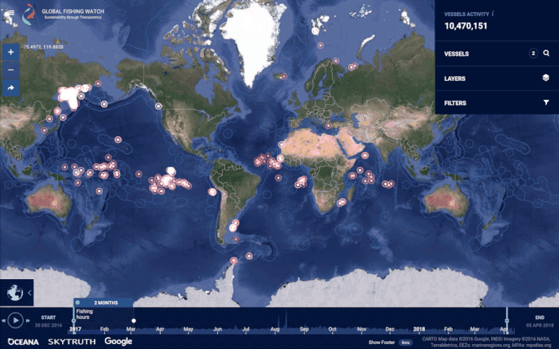
Global Fishing Watch (GFW) is a non-profit organisation launched in 2016 by conservation group Oceana, satellite technology consultancy SkyTruth and Google. Its chief responsibility is the Global Fishing Watch platform, which uses data collected from on-board tracking systems to map the movements of fishing vessels.
The aim of the platform is not only to help governments quell the scourge of illegal fishing, but also combat overfishing and habitat destruction by creating an accurate picture of the global fishing industry. Nevertheless, the addition of two new improvements, which aim to shine a light on night-time fishing activities and transhipment practices, could potentially have boosted the transparency of IUU fishing for government regulators.
Image courtesy of
Tracking fishers through AIS
GFW primarily tracks vessels via on-board automatic identification systems (AIS) – GPS-like devices that large ships use to broadcast their position, identity, course and speed. Ground stations and satellites collect this information, allowing a ship’s movements to be tracked no matter where they are around the globe.
GFW then channels this data through computer algorithms that identify patterns in ship manoeuvres. Fishers’ locations are dotted on a publicly available online map, which tracks the movement of around 65,000 commercial fishing vessels.
The implications of such a platform are wide for environmentalists, journalists and anyone tracking fishing trends. Most importantly, however, governments and authorities can identify boats that aren’t authorised to fish in their waters, or are fishing illegally in protected areas.

Fishers’ locations are dotted on a publicly available online map, which tracks the movement of around 65,000 commercial fishing vessels
“When you think of the impact on the societies that rely on fishing and the damage done to the ecosystem through the use of illegal gear or methodologies like trawling, [IUU fishing is] an area that needs to be closed down,” says GFW CEO Tony Long. He argues that a lack of available data has been a key problem for existing fishing regulations, which are often patchy or inefficient.
For example, under the Food and Agriculture Organisation’s Port States Measures Agreement suspected IUU fishers can be denied access to participating ports, but if they don’t have access to a vessel’s monitoring data, they are unable to tell where the vessel has been, or what it might have been doing.
Long says the GFW is of particular importance to those countries that are less equipped to deal with IUU fishing due to a lack of resources or established coastguard. One such country is Indonesia, which recently used GFW’s data to analyse the impact of new policies banning foreign fishing vessels from its waters.

Image courtesy of

Svein Kleven is senior vice president of engineering and technology for Rolls-Royce. Image courtesy of Rolls-Royce
Night-time fishing revealed
Under International Maritime Organization regulations, all fishing vessels weighing 300 gross tonnes and over are required to carry automatic identification systems, but for smaller vessels there is no such requirement.
According to GFW, vessels with AIS account for as much as 80% of fishing activity on the high seas. Nevertheless, there is still the potential for wayward vessel operators to intentionally disable their AIS devices, or report a series of false locations. Thus, there has been a need for new ways to track these problem vessels.
In June this year, GFW announced it had incorporated new low-light imaging data provided by the US National Oceanic and Atmospheric Administration (NOAA), which would allow the platform to track vessels that fish at night. According to GFW, the new night-time surveillance system detects between 10,000 and 20,000 boats that aren’t transmitting location signals.
The new night-time surveillance system detects between 10,000 and 20,000 boats that aren’t transmitting location signals

“The partnership we have with NOAA has allowed us to take all of the light that they can see out in the ocean, remove the static installations, land-based light, and information from shipping lanes, and leave a set of lights on the ocean that are likely to be fishing vessels,” says Long. “We can then layer our AIS and vessel monitoring system over the top of it, so you can see the [vessels] that are being compliant.”
The system has already led to new revelations about squid fishing, which usually occurs at night under bright floodlights. Data analysis found that of 200 Chinese vessels targeting squid off the coast of Peru, about 20% weren’t broadcasting a signal – indicating potential foul play.
New encounters on the Global Fishing Watch platform
Hauling hotspots identified
GFW also recently updated the platform with the first ever live global view of open ocean transhipment – the practice whereby fishing vessels transfer their catch to ships with massive refrigerated holds to carry back to port. Transhipment can allow IUU fishers to mix illegally caught fish with legal catches.
“If all of the fishing vessel’s catch is going into a transhipment vessel, and then that vessel meets other fishing vessels before it comes to port, you end up with large hold of fish that's associated with several different vessels,” says Long.
GFW developed the first ever global database of transhipment vessels, using a combination of registry data and machine learning techniques to identify roughly 680 ships. Data scientists then analysed more than 30 billion AIS signals to determine transhipment encounters and ‘hotspots’ at sea. Using this method, they found that more than half of transhipment behaviour identified using AIS may occur in the high seas, outside of countries’ jurisdiction.
Data scientists then analysed more than 30 billion AIS signals to determine transhipment encounters and ‘hotspots’
Long says that possibly nefarious vessels that flock to these areas could be targeted using the data. According to GFW, the transhipment dataset has already been used to identify vessels potentially involved in catching sharks that were illegally transported through the Galapagos.
“Generally, [transhipment vessels] sit within a regional fishery’s management jurisdiction,” Long says. “If we can show them how many transhipments happen in their area, they can count how many are authorised, match it against what we saw, and then go after the vessels that appear to be transhipping without authority.”

Night light vessel detection map on the Global Fishing Watch platform
Getting countries - and monitoring systems - on board
In the future, GFW is looking to bolster its platform with data from vessel monitoring systems (VMS), which are installed on many boats to send data specifically to government regulators.
Currently, few countries have made their VMS data public, but this could be set to change. Indonesia recently pledged its VMS information to GFW, adding 5,000 vessel locations to the platform. Peru has followed suit, and Costa Rica has signed a letter of intent to provide the same.
Long says that GFW’s overall ambition is to get 20 more countries on the system within the next five years. This could help the organisation achieve its goal of tracking vessels responsible for at least 75% of the global catch, covering all large industrial vessels and some smaller fishing vessels.
Indonesia recently pledged its VMS information to GFW, adding 5,000 vessel locations to the platform
VMS systems can still be tampered with and aren’t comprehensively used across all fishing vessels. Long says that ports should make it harder for fishers to avoid regulations, as well as encourage good behaviour moving forward, so that those on the fence about compliance will see the benefits of doing so.
“A vessel that’s willing to be tracked should have quick access to the port as a trusted vessel, land its fish and get back out to sea,” he says. “The very worst actors will have lots of information missing, and those vessels need to be brought in, inspected, and have appropriate action taken if there are discrepancies found.”
Filling in the gaps of GFW’s coverage will ultimately prove a challenge. However, as countries open up to the platform and introduce more regulations to crack down on IUU fishing, it seems that the culprits will be left with fewer places to hide.


